
This beautiful spot has recently been bought by the National Trust for £1.5 million, and it’s not hard to see why. It’s incredibly romantic, peaceful and wild, and this circular walk pairs this with some of Exmoor’s open moorland for a match made in heaven Devon.
Why it’s on my list
I have hazy childhood memories of walking in the Lorna Doone Valley. I remember parts that were by a river and were very pretty. Back then I’m sure I would have dragged my feet and moaned about going for a walk, but now is a different story! I wanted to rediscover this part of Exmoor and enjoy a nice walk with my parents, in what I hoped would be a quiet and uncrowded place (a Covid-secure walk you might say).
Walk Information
Location: Start in Malmsmead, where there is the National Trust car park and a cafe. It’s right by Badgworthy River, which is made characteristically Exmoor with both a stone bridge and a ford. The drive from Barnstaple is stunning around Countisbury. We had really clear views of Wales.
Parking: National Trust Lorna Doone Valley car park. £4 all day, free for National Trust members.
Length of walk: About 8 miles – allow 4 hours.
Type of walk: Circular walk including moorland paths by a river, open moor, farm fields. Really small bit on a road. Uphills are fairly gentle.
Dog friendly? Yes, but there are parts of farmland and road where you will need to have dogs on leads. There were electric fences in some parts that dogs will need to be helped with. Our dogs were off the lead for most of the walk.
Overall verdict
This is a brilliant circular walk that is hugely enjoyable for those who know the classic novel Lorna Doone by R.D. Blackmore, and those who don’t. The parts by the Badgworthy River were incredibly peaceful, and the bits by the oak trees had an air of magic about them. The open moorland was spectacular to see too – so wide, open and bare. A fantastic walk to introduce Exmoor.

The route
The route we followed is taken from Pathfinder Guides’ Exmoor and the Quantocks Walks. Get it from Amazon here.
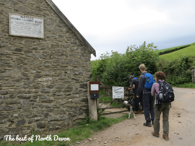
Starting from the National Trust car park, we headed over to the gate with a sign that says ‘Path to the famous Doone Valley’.
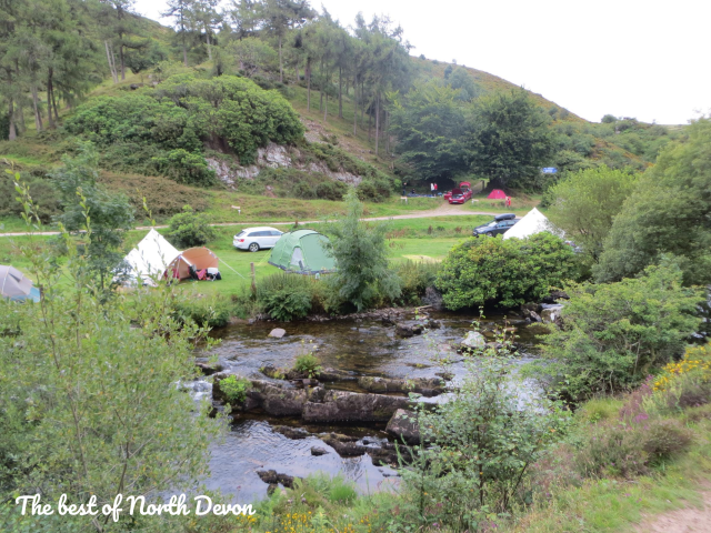
It was then just a case of following the river, passing Cloud Farm campsite (which looked fun!), through a wood of twisted oak trees, and over a small wooden bridge.
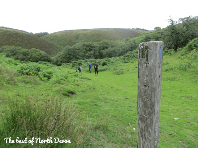
We turned off the track at the signpost pictured below to Tom’s Hill Barrows, where the path almost turned back on itself, but headed downwards.
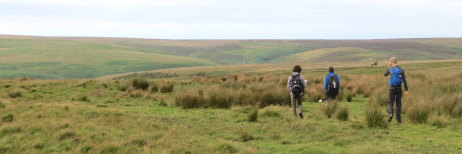
Following the river some more and then heading up a hill, we came to wide, open moorland. We took care to follow the map at this point, and we went through a gate on our right-hand side, which had a signpost by it.
We followed the wall, and then part way along this there was a sign for a bridleway gate 250m to the right, when we got to it this was signposted to Oareford.

We went through this gate and crossed the moorland, and eventually headed slightly downhill to another gate. We went through this and continued straight until we got to a point where the moor turned into farmers’ fields. There was a left-hand field and a right-hand field – the walk takes you through the fields on the left. There were a few small electric fences to navigate around.
After crossing through a few fields, there is a field that has a gate around halfway along with a yellow mark on one of the gate posts. This is the path to take, as the gate at the end of the field goes on to private land.
Following this path we came out on a bridleway, passed a church and into the village of Oare.

There is a short bit along the road here, and after turning right at the t junction (signposted towards Lynmouth and Porlock), there was eventually a bridleway on our left. This is signposted to Malmsmead.

We kept following signposts for Malmsmead and ignored the footbridge over the river, carrying on until we returned to the start of the walk.
The best
This could possibly be the most peaceful walk I have ever been on. And it was very Covid-secure – we saw hardly anyone. The scenery was absolutely stunning and it was great to see the variety of landscapes. There was a quiet and peaceful bit by the river and under the cover of wild, twisted oak trees, which contrasted with the broad open moorland – the only things breaking it up being a couple of trees here and there.


Not the best
The electric fences in the farm fields were a bit tricky to navigate. We couldn’t see a clear entrance or exit for walkers, so we jumped over them. This was no problem for us, but a little trickier for my parents’ dogs.
Top tip
A fair chunk of the walk involves moorland that is pretty much featureless. On a day where visibility isn’t very good, this bit could be very difficult to navigate. So do pick a good clear day to do this walk, unless you really know what you’re doing with an OS map and compass.
